 |
| Echo Bay, from the beach. A couple of camping kids play with sticks. |
Another glorious morning! Robert & Michelle take a kayak tour at
dawn to scope the place out. Upon
return, they report that a family of otters was frolicking in the water nearby.
 |
| Sucia geology |
At
every anchorage, one of the first things we must do is find those
all-so-important land-based toilets. Yes
we have a head (i.e. toilet) on board, but unlike the tropical areas we've
visited, they REALLY discourage boaters from dumping sewage anywhere near the
islands. Thus, we all avoid poop in the
head as much as possible. So that means
that each morning, anyone with the need must head for shore for their
"morning constitution". And
sometimes, that means a rather long kayak or dinghy ride, usually followed by a
steep stairway climb. Sucia Island is
part of the Washington State Park System, and as such, they have composting
toilets. Interestingly enough, these
toilets rarely have odor. Emily, our
onboard expert on waterless sanitation systems, approves of the design.
But one thing the Park System does NOT
provide is trash cans. Thus, we must bag
it up and save it till we get to a proper facility. After a few days, the trash aboard Escape starts to pile up.
At all of these remote parks, including
Sucia, there are always campers ashore, with their tents. Many were families with kids. They bring lawn chairs, stoves, ice chests,
and other creature comforts, and haul it from their nearby yacht via dinghy or
kayak. It's kind of a bummer, however,
that they cannot have campfires. How can
you camp without a campfire?!?
 |
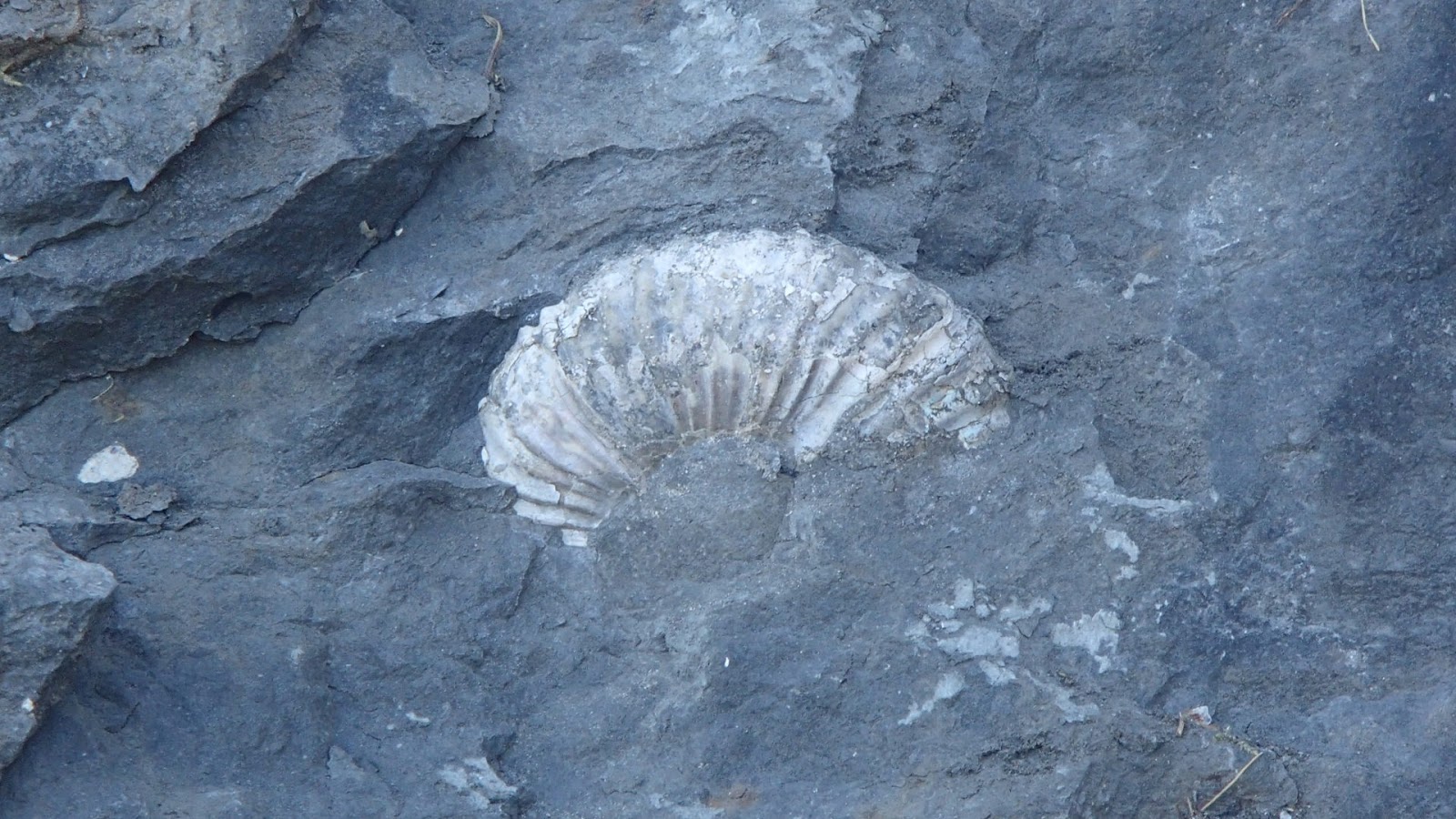
| Sign at Fossil Bay |
Robert has been really excited about
coming here to Sucia. Nearby Fossil Bay
was aptly named, and being a hardcore fossil hound, he was off early to
explore, "specimen bag" in hand.
He did find some fossils, but it turned out that actually gathering them
was prohibited. But, he got some great
photos.
 |
| Fossils everywhere, but you could only take photos. |
Echo Bay was a superb place for
kayaking. Mitch and I spent a good chunk
of the morning exploring the shoreline, above the shallow rocks. I had seen photos of the shore in the
cruising guide, but when you see those massive, fractured, layered, weathered,
high bluffs in person, you realize that the photos just don't do it justice. We also found a small SANDY beach tucked in a
small cove. (All the other beaches were
really gravel.) A lady was there playing
fetch with her two dogs.
 |
| David exploring by kayak in Echo Harbor |
 |
| and Mitch, too. |
Kayaks are the ideal vessel for this
kind of exploring. In a kayak, you can
go anywhere. In a way, kayaking was like
snorkeling, and a good substitute when the water was too cold. Yes you still need a dinghy for hauling
multiple people, provisions, and other stuff, but it's too bulky and noisy for real
exploring.
 |
| On the trail to Johnson Point. David in the foreground. |
Robert & I took the hike to Johnson
Point, the eastern-most tip of one of the "finger" peninsulas. Along the way we heard a knocking sound,
looked up, and saw a MONSTER-sized woodpecker hammering away at a dead fir
tree. And the end of the trail, we were
greeting with an awesome view - a 270⁰ panorama of the surrounding waterways,
about 50 feet up. Wow! Mt. Baker was off in the distance, and Orcas
Island was in the foreground. There was
a bench and some sort of geological survey marker. Powerful currents in the water below ripped
and roiled. On the hike back, Woody was
still hard at it up there.
 |
| Johnson Point. That's Robert in the foreground. |
 |
| Seals frolicking on the rocks |
We pulled up anchor at mid-afternoon for
our "sail" to Cypress Island, over in the eastern part of the SJI
archipelago. I say "sail" in
jest because, just like yesterday, the wind was a big fat zero. Again I must use that dreadful diesel
engine. This boat has SAILS - I want to
use them!
But, as we approached the eastern tip of
Orcas Island, I could see a different surface texture of water up ahead. And as we cleared the point and entered the
Rosario Strait, the wind came up. Raise
the sails! Engine off! Yes, life was good again.
However, a mere 20 minutes later, the
wind died as quickly as it came up.
Engine back on. Sigh.
 |
| Robert pulled this monster seaweed off our rudder. |
We entered Eagle Harbor, on the east side
of Cypress Island. This was to be our
"staging" anchorage for our final leg into Anacortes tomorrow
morning.
Fill in the blank: Eagle Harbor was __________.
If you said "gorgeous", you are
correct! Heck, ALL of the places we went
were gorgeous! Eagle Harbor was a bit
smaller than the others, had high barren rock walls, and a perfect view of Mt.
Baker. About a dozen boats were
there. First things first: drop the kayaks, go exploring, find the
toilets.
The map at the trailhead ashore showed a
half-mile hike up to Duck Lake. Hey - a
lake - with ducks! What's not to
like? So Emily and I took off on the
rather steep trail that looked like it hadn't been maintained for awhile, so it
was sorta in its "natural" state.
Clearly, it was the path less traveled.
 |
| This is Duck Lake?!? |
Well, it turned out that Duck Lake was
rather overgrown with reeds, lilly pads, and other vegetation so thick that you
couldn't even see the water. There was
even the remains of what USED to be a bench long, long ago. No ducks, tho. Well anyway, it was a nice side trip.
After dark, the sky above was ablaze with
millions of stars. The Milky Way stood
out like a swath of white paint.
 |
| Robert & Michelle, with Mt. Baker in the background |


No comments:
Post a Comment